The Story Behind “The Flats”: A Hidden Piece of Indigenous History
By Jenni Barrientos, Assistant Archivist, Community Development
Observed each June, National Indigenous History Month recognizes the diverse cultures, traditions and contributions of First Nations, Inuit and Métis Peoples. It’s an opportunity to deepen understanding of Indigenous histories and perspectives, while reflecting on the ongoing impacts of colonization and the path toward reconciliation.
In the Medicine Hat region, that recognition connects to a much longer story, one rooted in the land itself, where Indigenous communities have lived, travelled and shared knowledge for generations. That history is still reflected in the places we know today, sometimes in ways that aren’t immediately obvious.
Yuill, Old Townsite, Purmal subdivision, The Flats, the River Flats … the area near the South Saskatchewan River in Medicine Hat has had quite a few names over the years. Yet, how did “The Flats” come to be? Is it simply because the area is flat in topography? Actually, it is a lesser-known nod to our Indigenous history, because “The Flats” is short for the area’s long-used name: The Moccasin Flats.
A letter to the editor of the Medicine Hat News details: “For the past 80 years, that portion of the city north of the CPR tracks has been known as “Moccasin Flats.” The name may not be on any map of the city, but we long-time residents will continue to call it the Moccasin Flats, no matter what other name [anyone else] may christen it.” – Jack Babbit, Medicine Hat, November 12, 1962. Since at least the late 1880s the area had been known as the Moccasin Flats and has a deep significance to our Métis and Indigenous populations, as it also encompasses the settlement area of Saratoga Park, the coulees overlooking Seven Persons Creek and Ross Creek, and is where these waters meet the South Saskatchewan River.
For example, Patrick Laframboise (b. 1903 – d. 1990), a local Métis elder, described his upbringing by saying: “I don’t know if I was born in the old hospital or at home, but we lived on Moccasin Flats which was towards Strathcona Island. Medicine Hat was more a native town in those days and Strathcona Island only a porcupine’s nest.”
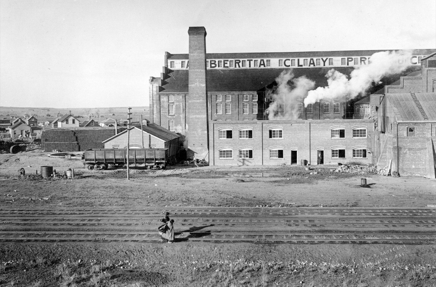
The Moccasin Flats have always been a blend of industrial, residential and recreational, including the site which was home to Medicine Hat’s manufacturing center, with industries such as: Alberta Iron Rolling Mills, Alberta Clay Products, Alberta Foundry and Machine Company and Medicine Hat Pump and Brass, to name a few.
Since many Métis and Indigenous people found jobs in these manufacturing areas during the industrial boom in those early years, they would often walk across the spur line tracks near what is today Carry Drive/South Railway Street or Scholten Hill, to get to and from home near Saratoga Park. It is perhaps this walk, done in moccasins, which coined the name of the Moccasin Flats. The attached image, dated ca. 1912, appears to show just that: a pair of Indigenous women walking along the tracks in front of Alberta Clay Products, with moccasins on their feet. This area has always had a special significance to our Métis and Indigenous citizens, as a meeting place of waters and of people, and it is no surprise that the meaning was solidified with the importance of the name: The Moccasin Flats.
You can hear Patrick Laframboise’s 1978 oral history interview in the Archives collections here.
Stay up to date.
Subscribe to eNotifications to stay connected with City of Medicine Hat news, activities, events, programs, operations and more.


